Study,on,the,Sediment,Transport,Flux,and,Mechanism,in,the,Bohai,Strait,at,the,Tidal,and,Monthly,Scales,in,Summer
时间:2023-04-16 20:00:03 来源:柠檬阅读网 本文已影响 人 
YUAN Xiaodong, FENGXiuli, 2), HU Rijun, 2), , JIANG Shenghui, 2), and ZHONG Wei
Study on the Sediment Transport Flux and Mechanism in the Bohai Strait at the Tidal and Monthly Scales in Summer
YUAN Xiaodong1), FENGXiuli1), 2), HU Rijun1), 2),*, JIANG Shenghui1), 2), and ZHONG Wei1)
1),,266100,2),,,266100,
Based on the data of tidal currents and suspended sediment concentrations observed synchronously at 11 stations in the Bohai Strait lasting for 25 hours, the temporal and spatial variations of currents and suspended sediment concentrations in the Bohai Strait in summer were analyzed. The Study preliminarily discussed the transport mechanism, transport trend and transport flux of suspended sediments in summer, using flux-mechanism decomposition method and numerical simulation. The suspended sediment transport was mainly controlled by advection and next influenced by vertical net circulation, while resuspension is relatively weak in Bohai Strait. The single-width fluxes of investigation stations varied from 3.8 to 89.1gm−1s−1, with the maximum value in Miaodao Strait. The suspended sediment transport trends in Laotieshan channel along the vertical section are obviously distinct. The waters mainly flow out of the Bohai Sea in surface layer, while into the Bohai Sea in bottom layer. However, the transport trends of other channels in the centre and south are consistent vertically. The sediments in the Bohai Strait follows the transport pattern of moving outward from the south and inward from the north in summer,., the sediments are carried out of the Bohai Sea through the Laotieshan channel, while into the Bohai Sea through other channels. And the outflow flux exceeds the inflow flux in August with the net water flux of 1.4×10¹⁰m3, basically same as the deliveries of the rivers into the Bohai Sea. Moreover, the suspended sediment flux is 0.33 Mt under the action of tidal residual currents in the Yellow Sea in August.
Bohai Strait; suspended sediment transport; numerical simulation; summer
The Bohai Sea is a semi-enclosed shelf sea surrounded by the mainland and in contact with the Yellow Sea throughthe Bohai Strait, thereby rendering the Bohai Strait–the only channel for sediment transport out of the Bohai Sea. The Bohai Sea has received a large number of river sediments, especially from the Yellow River that delivers about 1.10 billion tons of sediments every year (Milliman and Meade, 1983), 80% of which were mainly delivered into the Bohai Sea during the summer flood season (Bi., 2011). Due to the weak hydrodynamics, sediments are captured in the estuary by the stratification and sheer front (Li., 2001;Zhao., 2001; Wang., 2007), 70% of which are deposited within 30km of the estuary (Martin., 1993). Sediments are mainly transported out of the Bohai Sea in the form of suspended particles, and the annual suspended sediment flux (SSF) from the Bohai Sea to the Yellow Sea can reach millions of tons according to previous studies (Bornhold., 1986; Martin., 1993; Bi., 2011).
Hence, the study of suspended sediment transport through the Bohai Strait is of great significance to the ecological environment, physicochemical cycle and sediment source in the Bohai and Yellow Sea (Lin, 2002; Qiao, 2008; Wang., 2014; Xiao., 2015).
Numerous studies have investigated the suspended se- diment transport through the Bohai Strait. Qin. (1986) first proposed that suspended sediment transport through the Bohai Strait follows the pattern of moving outward from the south, and inward from the north, whereby suspended sediments are delivered into the Bohai Sea from the north and out from the south under the prevailing northwest winds in winter. This trend has been confirmed through observation and numerical simulation by oceanographers (Huang., 1996; Fang., 2000; Wang, 2011). Recent studies have focused on winter or seasonal transports in the Bohai Strait. Bi. (2011) examined the seasonal variation of suspended sediment concentrations of the Yel- low and Bohai Seas and calculated the suspended sediment flux throughthe Bohai Strait as 40Mt based on multi-sites investigation and satellite images. Extreme weather con- ditions in winter also have important impacts on the sedi- ment transport (Wu., 2019; Duan., 2020; Wang., 2020). Wang. (2020) restored the response pro- cesses of the circulation systems and the sediment transport patterns to the north wind throughobservations andnumerical modeling simulations. They also clarified the contributions of various mechanisms to the sediment trans- port. Meanwhile, Wu. (2019) presented a novel, phase- averaging method to estimate the net suspended sediment fluxes and found a net westward sediment transport into the Bohai Sea in result of intermittent but frequent sou- therly winds in northerly-wind dominated winters. How- ever, due to theweak hydrodynamics in summer and the influence of numerous islands in the Bohai Strait, the trendsand dynamic mechanisms of the suspended sediment trans- port of the Bohai and Yellow Sea in summer remain con- troversial. Zhao(1995) proposed that the tidal re- sidual currents are the main hydrodynamic force in sum- mer using the numerical simulation in the Bohai and Yel- low Sea. This finding was confirmed a posteriori truth by other studies (Huang., 1999; Wei., 2003). The total tidal flux of the Bohai strait is nearly 1.2×10¹¹m3, of which the tidal flux of the Laotieshan channel accouts for about 68% (Jiang., 2019). As for the transport trends, Zhang. (2018) observed that waters of the Bohai Sea flow to the Yellow Sea throughthe northern and southern surface layers of the Bohai Strait in summer and revealed the sediment transport into the Yellow Sea by analyzing sea-level changes.
Most previous investigations mainly focused on the sea- sonal variations and the sediment transport under the extreme weather in winter, but few on the short time scale in summer, especially under the influence of residual cur- rents (Li., 2015). Hence, this study provided an ana- lysis of the temporal and spatial variations of currents and suspended sediment concentrations in the Bohai Strait in summer. Tidal currents and suspended sediment concen- trations were observed synchronously at 11 stations in the Bohai Strait, lasting for 25h. The transport mechanism,trend and flux of suspended sediments in summer are then examined by using the flux mechanism decomposition method and numerical simulations. The results of this study
are expected to be important to help better understand the underlying mechanism of sediment transport in Bohai Strait under the strong residual currents associated with the tidal fluctuations in Summer.
The Bohai Strait, which is located on the south of Lao- tieshan of Liaodong Peninsula and the north of Penglai of Shandong Peninsula (Fig.1), has the shortest length of only 109km. The islands in the central of the Bohai Strait divideit into three distinct parts: the south, the central and the nor- th parts (Fig.1). In the south is the Miaodao Strait (Fig.1; D5), which has a shallow depth of nearly 20m and a width of 6.4km. It is the main channel for the sediment transport from the Bohai Sea to the muddy area of the Yellow Sea (Bi., 2011; Wang., 2014). The central part, south from Changshan island and north to Beihuangcheng (Fig.1; D4–D2), are densely distributed by islands with complex waterways and circulations. In the north, the Laotieshan Channel (Fig.1; D1) possesses the widest width of 42km, which occupies 2/5 of the entire Strait. It is the main channel of warm waters in the Yellow Sea to enter the Bohai Sea (Qiao, 2008). Due to the strong scour of tidal currents, there are tidal ditches with depth of exceeding 60–80m in the south of the Laotieshan channel (Qin, 1986), whichmakes it the widest and deepest channel of the Bohai Strait.
3.1 Currents and Suspended Sediment Concentrations
Eleven continuous observational stations were set in the Bohai Strait on August 3, 2016 (Fig.1). The observational time was extended from 10:00 on August 3 to 10:00 on August 4, with a one-hour interval. GPS positioning was used in all the stations, while electromagnetic current meter(model: JEF AEM213-D; accuracy: ±1cms−1) and Acoustic Doppler Current Profiler (model: FlowQuest 600kHz; ve- locity accuracy:±2.0mms−1) were used to measure tidal currents. Stations with electromagnetic current meters were observed in six layers (surface layer, 0.2H, 0.4H, 0.6H, 0.8H and bottom layer) divided according to the water depth. Simultaneous tidal level observations were conducted at Beihuangcheng, Penglai western harbor and Gangluan wharf (Fig.1).

Fig.1 Location and stations of study area in the Bohai Sea and Yellow Sea. (a), the red arrows represent the summer circulations (Fang et al., 2000); the black arrows represent the winter circulations (Guan, 1994). (b), red dots indicate current stations; green dots indicate tidal stations;D1 section, Laotieshan channel; D2 section, Daqindao to Beihuangcheng Channel; D3 section, Tuoji to Daqindao channel; D4 section, Changshan to Tuoji channel; D5 section, Miaodao Strait.
Suspended sediments were taken synchronously along with the currents measurement, whereby at station 6#, 7#, 8# and 9# water samples were taken in three layers, while at the other stations samples were taken in six layers. Subsequently, the suspended sediment concentrations (SSC) at each time were derived by laboratory filtration, drying, weighing and calibration of the water samples. Meanwhile, the calibrations were made once every 10 measurements by using double filters: the upper measured the suspended sediment concentrations, and the bottom made the correction. The measurement error did not exceed 10%. The formula is as follows:

whereWis the total weight of the filtration membranes and samples,Wis the weight of the air filtration membrane, andWis the blank correction value which can be calculated by the following formula:
whereWis the weight of the blank corrected filtration membrane after filtration,Wis the weight of the blank corrected filtration membrane before filtration, andis the number of blank corrected filtration membranes.
3.2 Flux Mechanism Decomposition Method
The flux mechanism decomposition method (FMDM) is a reliable method to study suspended sediment flux at alocal and global scale (Bowden, 1964; Zhu., 2005) and has been widely used to examine the suspended sedi- ment transport in Estuaries and shelves (Jay., 1997; Hu, 2009). In this investigation, the single-width FMDM was used to analyze the suspended sediment transport and the impact of various dynamic factors in the study area. The method is not only able to reflect the advection trans- port of suspended sediments but also can better show the role of vertical shear transport and tidal pump transport.
Ingram (1981) and Uncles. (1985) proposed the use of relative water depth to decompose instantaneous mass transport, which uses(0≤≤1) to represent the relative water depth and x to express ordinate. The instantaneous velocity ((,,)) can be divided into the sum of the mean value of the vertical line and its partial terms excluding the fluctuations of velocity.

The instantaneous velocity can be decomposed as follows:

Similarly, the sediment concentrations can also be decomposed as follows:

The formula for calculating the average instantaneous single-width suspended sediment flux in tidal period is expressed as follows:

where T1represents the Euler residual current contribution, T2represents the Stokes draft contribution, T3represents the related terms of tide and suspended sediment va- riation, T4represents the relevant terms of suspended se- diment and tidal current change, T5represents the relevant terms of vertical velocity change and SSC change, T6and T7represents the shear diffusion caused by mean volume and tidal vibration shear, T8represents the vertical tidal oscillation shear.
3.3 Numerical Simulation of Tidal Currents
3.3.1 Model description
Mike 3 unstructured fluid model was used to develop anumerical simulation model of Hydro Dynamic (HD) mo- dule to simulate the tidal current field. The model used unstructured triangular meshes, which were flexible enough to fit the land-sea boundary well, and could be controlled according to the need to divide the computational domain. The model has been effectively applied in oceans, shelves and estuaries (Huang., 2013; Fairley., 2015; Qiao., 2016). Mike 3 is based on the Boussinesq hypothesis, which is derived from the three-dimensional incompres- sible RANS equation (Reynolds averaged Navies-Stokes), as well as the hydrostatic hypothesis. The free surface in the 3-D model is defined by usingcoordinate transformation method. Inaddition, the spatial range is subdividedinto continuous non-overlapping elements by finite elementmethod. In this model, unstructured grids were used horizontally, while structural grids were used vertically. Five layers were set to reflect the tidal current from surface to bottom, with a respective value of 0.2 evenly set for each layer. This computational domain included the sea area surrounded by A (Jiming Island in Shandong Province), B (Dengsha River in Liaoning Province) and the coastline (Fig.2). Then, based on the observation data of A and B, the four main tidal component harmonic constants M2, S2, K1and O1were calculated.

The bed roughness is controlled by Manning’s coefficient(=32m1/3s−1for bottom friction), and the dimensionless empirical Smagorinsky coefficient is set as 0.28. Moreover, the horizontal eddy viscosity coefficient is calculated by theSmagorinsky formula considering the sub- scale grid effect, and the expression is as follows:

whereis the horizontal eddy-viscosity coefficient,cis constant andis the characteristic mixing length,Sis deformation rate, which is calculated by

In order to reveal the tidal current situation of the study area, the simulation grids of the Bohai Strait have been partially densified. The simulation time was set to 61 days from July 15 to September 15, 2016, and the paper selects the data of whole August to calculate the residual tidal cur- rent and suspended sediment flux.

Fig.2 Model calculation domain and grids.
3.3.2 Model validation
The simulated tidal data were validated by the measured data from August 3 to August 4 in 2016 at Penglai western harbor (T1), Beihuangcheng (T2) and Gangluan wharf (T3) (Fig.3). The absolute differences of the highest tidal level vary from 0.01m to 0.08m, and the average differenceis 0.05m; the relative differences vary from 1.64% to 12.54%, with an average relative difference of 7.36%. The absolute differences of the lowest tide level vary from 0.06 to 0.07m, and the average difference is 0.07m; the re-lative differences vary from 7.21% to 12.30%, with an average relative difference of 9.31% (Table 1). The simulated tidal level is essentially consistent with the measurements.Moreover, the results showed the current features simulated with the numerical model agreed very well with the observation data recorded at the 11-station data (Fig.4).In most cases, the simulated tidal currents are also in goodagreement with the measured data for all the stations. None- theless, slight differences remain at certain times between the measured and the simulated tidal current velocities, with a maximum mismatch of around 0.16ms−1. This dis- crepancy may be because the changes of currents induced by wind and wave variations are not considered in the si- mulation. In short, the numerical simulation results remain reliable and be used to explore the suspended sediment transport subjected to residual currents under summer tidal fluctuations.
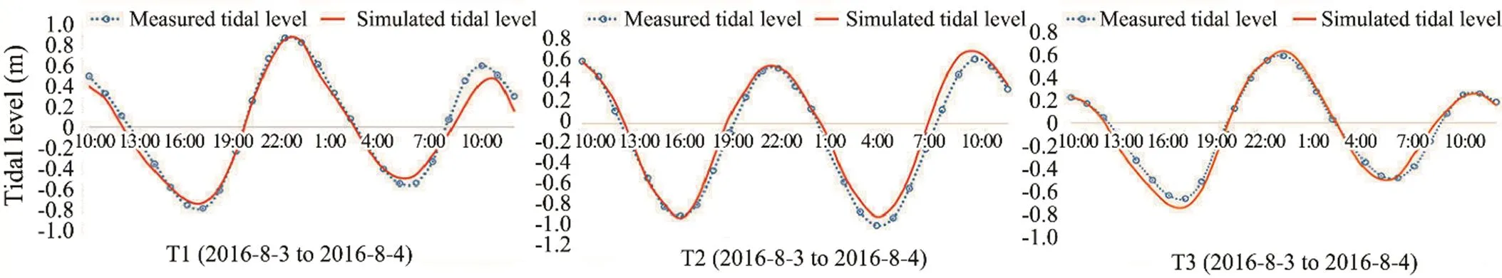
Fig.3 Comparison of simulated and measured water levels.

Fig.4 Comparison of simulated and measured currents.

Table 1 Comparison of simulated and measured tidal level values

4.1 Results of Measured Velocities and Suspended Sediments
4.1.1 Tidal current characteristics
The tidal currents are irregular semi-diurnal and shows strong reciprocating flow near the Shandong Peninsula, whose reciprocating directions are parallel to the coast of Shandong Peninsula. The reciprocating currents are nonetheless weak at station 7# in the northern part of Bohai Strait (Fig.5). The average velocities at each station rangedfrom 29.8 to 73.4cms−1during the observation period. The maximum value appeared at station 1# in Miaodao Strait, with a direction of 270˚, while the minimum value was at station 3# with a direction of 70˚. The energy of the tidal currents in the Bohai Strait was relatively large and the tidal current was the main hydrodynamic force (Qin, 1986). The maximum velocity could reach up to 1.51ms−1, which occurred on the flood time of surface water at station 1#.
The Euler residual currents of each layer at each station were calculated according to the measured data, shown in Fig.6. The velocities of residual currents in the study area ranged from 1.5cms−1to 25.0cms−1. The maximum value occurred in the surface layer of station 1# in Miaodao Strait with a direction of 295˚, while the minimum value occurs in the middle layer of station 8# with a direction of 262˚. The horizontal distribution of the residual currents was characterized by a ‘high in the middle, and low in the east and west’ trend,., the residual currents at the stations in the Bohai Strait were stronger than those at the stations in the Bohai Sea and the Yellow Sea, which was mainly attributed to strait-channel effects (Chen, 2000; Zuo., 2012). When the water flows through the narrow Bohai Strait from the open sea during the flood and ebb tide, the water cross section becomes narrow rapidly, thereby causing the currents to converge, the energies to concentrate and the velocities to increase. Moreover, the average velo- city of ebb tide is greater than that of flood tide, and the duration of ebb tide (for example, 7.5h at station 1#) is longer than that of flood tide (6h). The ratio of the average velocity of ebb tide to that of flood tide increased significantly from 1.30 to 2.14 from station 11# in the Yellow Sea to station 1# in the channel, and decreased down to 1.49 at station 2# in the Bohai Sea. Obviously, the exis- tence of the channel increases the tidal current asymmetry, making the residual currents in the channel stronger than those on both sides. Vertically, the residual current velocities decrease from the surface to the bottom because of the bottom friction (Table 2). There are little differences in the surface, middle (0.6H) and bottom residual current directions near the shore of Shandong peninsula, indicating the uniform mixing of surface and bottom water due to the strong tidal currents. Some differences were recorded at the stations off the shore. According to previous studies, the existence of thermocline renders difficult to the exchange of the waters between the surface and the bottom (Beardsley., 1992;Wang., 2014a), so the currents are different along the vertical axis.

Fig.5 Changes of vertical average currents at each station.
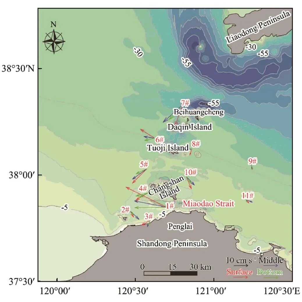
Fig.6 The distribution of vertical residual currents at each station. Red arrows, residual currents of surface layer; bluearrows, residual currents of middle layer; green arrows, re- sidual currents of bottom layer.
4.1.2 Spatial and temporal distribution of suspended sediments
The average suspended sediment concentrations in the study area varied in the range 15.4–41.0mgL−1. The ma- ximum and minimum values appeared at station 1# (Miaodao strait) and station 6# (north of the Bohai Strait), respectively. The distribution of thes is followed a trend ‘high in the South and low in the north, high in the West and low in the east’ (Fig.7),., thes of Bohai Sea are high while the concentrations of the Yellow Sea are low. Similarly, the concentrations around the Shandong Peninsula are high while the concentrations in the offshore area are low. Vertically, thes increase from the surface to the bottom.s tend to be high in bottom layers because of the resuspension, or advection transport of resuspended sediments in Laizhou Bay (Wang., 2011). The depth of the Bohai Strait increases from south to north, so the probability of resuspension in the southern channel is higher under the strong tidal current.Lin (2017) derived the sediment resuspension velocities, and suggested that sediments could resuspend in the process of ebb and flood.However, the resuspension occurs only in part of the time when the current velocities are large enough based on the comparison ofs and velocities (Fig.8). Moreover, except for stations 2# and 3#, the extreme of thes at the other stations corresponds to the extreme velocity magnitude.However, the extreme of thesat 2# and 3# stations lags 1–2h behind the velocities. In addition, there are two cases mentioned above (not found) at station 1# that are in the Miaodao Strait. Thes at the station 1# in Miaodao Strait, which is the most important channel for the Bohai sediment transport to the outer sea (Qin., 1986; Wang., 2014), was in a high concentration state during the observation time. Therefore, resuspension may not be the main way of suspended sediment transport in the study area. The suspended sediments in the Bohai Strait have two sources: local resuspension and transportation of resuspended sediments in Laizhou Bay (Martin., 1993; Jiang., 2019). Wang. (2014) revealed that suspended sediments are mostly supplied by the advection of the resuspended solids in the Laizhou Bay and Yellow River, while the local resuspension is relatively small in Bohai Strait. Hence, the transport mode in the study area will be thoroughly discussed, and the importance of advec- tion transport will be analyzed in the discussion.

Table 2 Residual currents of surface, middle and bottom layers

Fig.7 Suspended sediment concentrations of surface (S) mid- dle (0.6H) (M) and bottom (B) layers at each station.
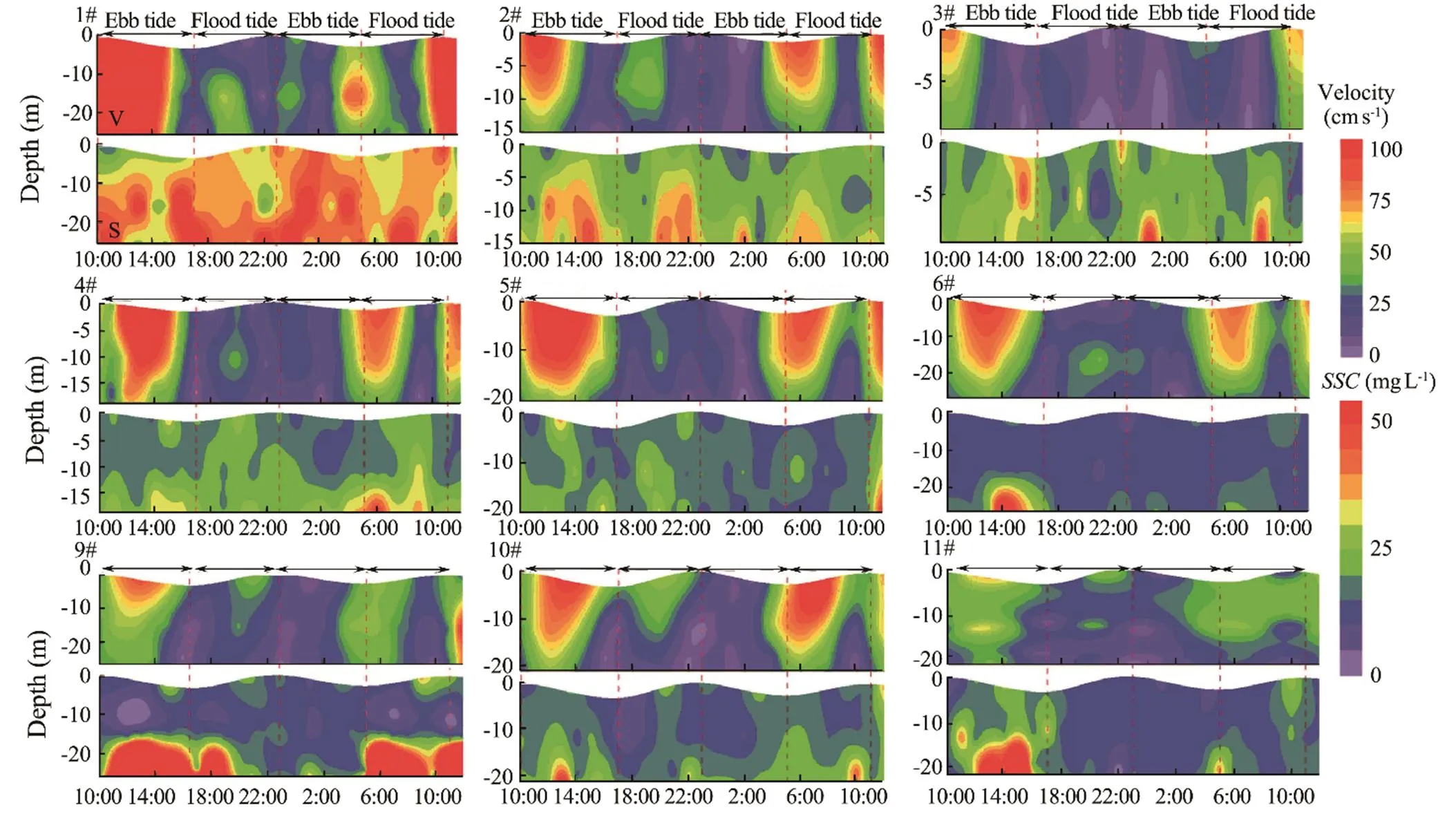
Fig.8 Variation of suspended sediment concentrations and current velocities with time.
4.2 Results of Simulated Currents
Four moments are selected to analyze the change of tidein a tide period, including the high tide, middle of ebb tide, low tide and middle of low tide. The currents in the study area are in form of obvious standing waves (Qin., 1986),., the flow velocities reach the lowest at high tide and low tide, while the flow velocities reach the maximum at the middle of ebb tide and flood tide. The direction of si- mulated flood tidal currents is from Bohai Sea to Yellow Sea, and. At high tide, the velocities in Bohai Strait are generally low, being higher in the south of Liao- dong Peninsula, the tail of Changshan and the coast of Shan- dong Peninsula, with a maximum of 1.0ms−1; the velocities in the Bohai Sea and the Yellow Sea are lower than in the strait, being less than 0.6ms−1(Fig.9a). During ebb tide, the waters in the study area flow from the Yellow Sea to the Bohai Sea. At the middle of ebb tide, the magnitude of the velocities in the whole Bohai Strait are larger than those in the Bohai Sea and the Yellow Sea, and the maximum velocities can reach up to 2ms−1, which appear in the south of Liaodong Peninsula and the tail of Changshan (Fig.9b). At low tide, the velocities reach the lowest values in a tide period, not exceeding 0.4ms−1, and the flow direction changes from the west to the east (Fig.9c). During the flood tide, the waters flow from Bohai Sea to Yellow Sea, and the velocities reach the maximum in the middle of flood tide, yet with smaller magnitudes than those in the middle of ebb tide (Fig.9d).
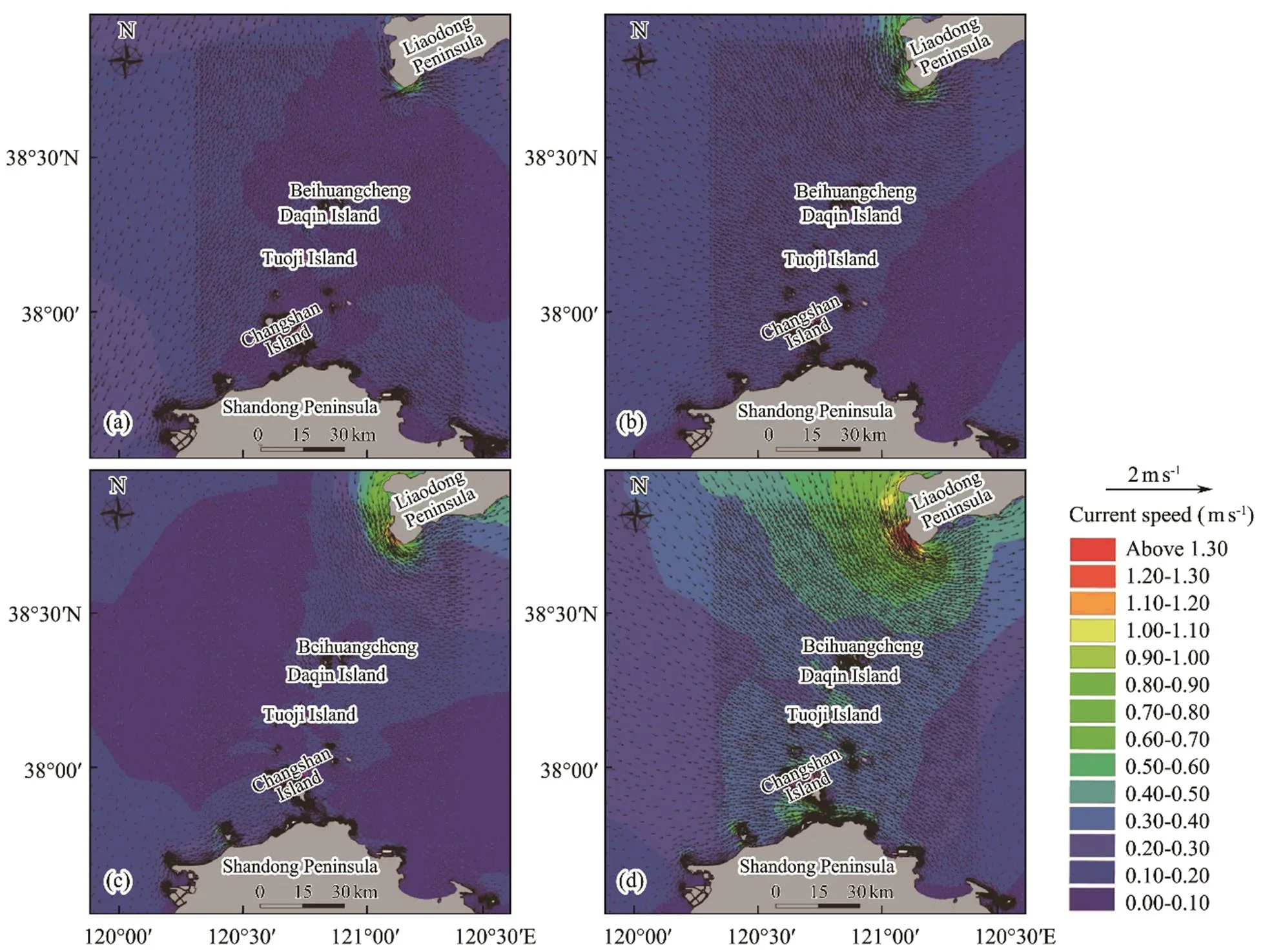
Fig.9 Simulated current distribution. (a), high tide; (b), middle of ebb tide; (c), low tide; (d), middle of flood tide.
5.1 Sediment Transport Mechanism at the Tidal Cycle Scale
The FMDM was adopted to explain the distribution, thetransport mechanism and the transport process of suspend- ed sediments in the study area. The results show that thes are between 3.8–89.1gm−1s−1at all of the 11 stations.Moreover, the SSF direction of 2#, 10# and 11# is from Bohai Sea to Yellow Sea, as opposed to the other stations. The maximum and the minimum values appear at the station 1# and station 8#, respectively. The magnitude of eachcontribution shows that T1, T2and T5were dominant, tidal pumping effect (T3+T4) and shear diffusion term (T6+T7+T8) accounted for smaller proportions. Advection item (T1+T2) is the comprehensive sediment transport effect of the Euler residual currents and the Stokes drafts, which is not only related to the residual current values, but also to the average sediment concentrations and water depths in a local tide cycle(Hu., 2016). In addition, the vertical net circulation transport item (T5) is induced by the differences of residual currents vertically and the inhomogeneous vertical distributions of suspended sediments in the Bohai Strait. The vertical difference of residual currents and suspended sediments are mainly involved in the item T5, not the tidal pumping effect (Table 3). As is shown in Table 3, the advection (T1+T2) has the greatest contribution to the whole research area, which is consistent with the previous studies (Qin., 1989; Wang., 2011), followed by T5. In addition, the Euler residual current contribution (T1) accounts for the most important proportion in the sediment transport (Lu., 2011).
The SSF per unit area in the southern part of the Bohai Strait is the largest in the whole Bohai Strait (Fig.10), where advection transport is predominant. Based on the measured data and previous studies (Zhao., 1995; Jiang., 2019), advection plays an important role, especially at station 1#, whereby T1is the most important part that determines the main directions of suspended sediment trans- port. The characteristics of transport flux correspond to those of residual currents, indicating that the southern part is an important channel for sediment transport in the Bohai and Yellow Seas and that Euler residual currents are particularly important for suspended sediment transport. The vertical net circulation also has an influence on the suspended sediment transport, mainly because of the vertical intensity variation of suspended sediment concentrations and intensity difference of residual currents vertically. Tidal pumping effect (T3+T4) accounts for a certain proportion, which is inferior to T5. This indicates that the resuspension occur in Miaodao Strait, but not the main pattern of suspended sediment transport.

Table 3 Suspended sediment flux (gm−1s−1) and direction (˚) in each transport item
Notes: T1+T2represents advection, T3+T4represents tidal pumping effect, and T6+T7+T8represents and shear diffusion term.
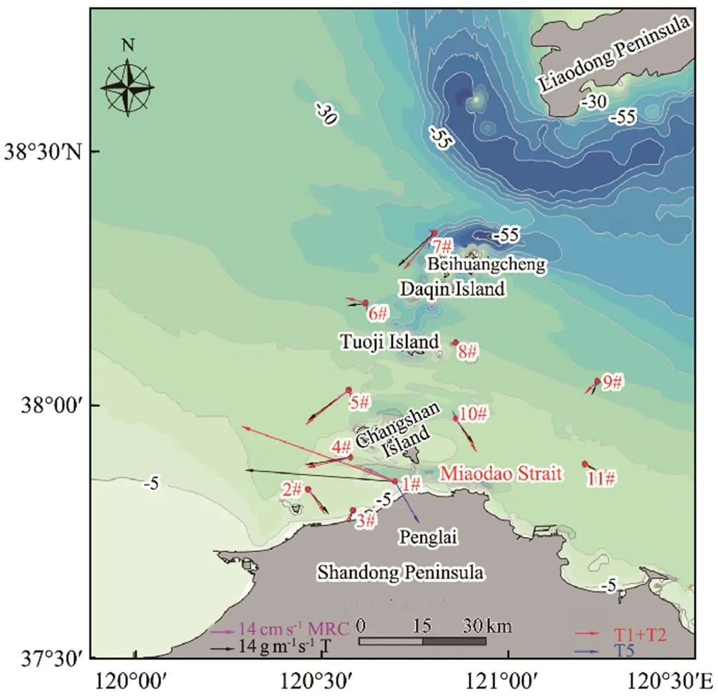
Fig.10 Comparison of T, (T1+T2), T5 and measured residual currents (MRC) at each station.
The SSFs of stations 2#, 3#, 4#, 5#, 10#, and 11# in the central and southern Bohai Strait are lower than those of Miaodao Strait.Advection is the dominant factor, but the proportion of T5in sediment transport has decreased significantly. These stations are distributed in the open water area, unlike 1#, which is distributed in the narrow channel and is affected by the channel effect. Therefore, the tidal currents are not as strong as those at station 1# (Fig.6), andtidal pumping effect is relatively low. Moreover, in the sou- thern Bohai Strait, the temperature and salinity are relatively uniform along the vertical profile (Wan., 2004; Yuan, 2018). In addition, the vertical variation of suspend- ed sediment concentrations is uniform and the deviation is relatively small. Although the vertical net circulation remains the second largest transport mechanism, it is still substantially smaller than the advection (Table 3).
The SSFs at stations 6#, 7#, 8# and 9#, distributed in the central and northern Bohai Strait, are generally smaller. According to Section 3.2, the great direction difference of residual currents can reach 62˚ and thes in the bottom layers can be twice as high as those in the surface layers, so the vertical differences of residual currents and SSCs are large enough to increaseT5(Table 3). Nevertheless, tidal pumping effect is still too small to have effect on the sediment transport in the study area. The T5of the stations in the North Yellow Sea accounts for a larger proportion than that of other areas and the vertical net circulation affects the net sediment transport alongside with advection (T1+T2). Hence, the suspended sediment transport is mainly controlled by advection and supplemented by vertical net circulation.
5.2 Net Sediment Transport Trend at Monthly Scale
The study area are divided into two layers vertically, namely the surface layer and bottom layer, in order to facilitate the study of vertical suspended sediment transport characteristics. The distribution of simulated tidal residual currents in August are similar to those of measured residual currents,., there is a trend of ‘high in the middle, low in the east and west’ (Fig.11). The residual tidal currents in the channels of the Bohai Strait are higher than the Bohai Sea and the Yellow Sea, and there are three high-value areas: the coast of Shandong Peninsula, the area around Miaodao Islands and Loatieshan channel. The maximum residual currents in the study area occur at the tail of Chang- shan in the northern part of Miaodao Strait, with a value of 56cms−1. According to the analysis of Section 4.1 and previous studies, tidal residual currents are the most important hydrodynamic factor for suspended sediment trans- port in the study area, which play an important role in sediment exchange in the Bohai Sea and Yellow Sea, and are the main dynamic factors for long distance transport of suspended sediments (Li., 2010). Therefore, the simulated residual currents can represent the transport trends of suspended sediment in summer.
Regarding the transportation direction, the Bohai Strait generally has an outward transportation from the south, and inward from the north. In the Laotieshan channel, there are obvious changes in the suspended sediment transporttrends vertically, whereby the main transport directions are outflow from Bohai Sea in surface layer, and inflow to Bohai Sea in the bottom layer. While there are two eddies at the bottom, clockwise in the north and anti-clockwise in the south, the main transport direction is toward the Bo- hai Sea. Moreover, the waters entering Bohai through Lao- tieshan channel divide into three parts. The first part flows clockwise into the Liaodong Bay, the second part moves westward into the Bohai Sea, and the third part moves counterclockwise to the south, which is consistent with pre- vious observations of Bohai circulations in summer (Guan, 1994; Zhao., 1995) (Fig.1). Furthermore, the waters flowing to the south from the Laotieshan channel can reachthe Miaodao Strait through the archipelago. In the southern and central part of Bohai Strait, the residual current direc- tions are generally consistent along the vertical direction, which is mainly eastward to the Yellow Sea. Moreover, there are multiple eddies in the central Bohai Strait due to the numerous islands, channels and complex topography, such as the eastern vortex of Changshan Island (Fig.11).

Fig.11 Distribution of simulated residual currents in August. (a), surface layer; (b), bottom layer.
5.3 SSF in the Bohai Strait at Monthly Scale
In order to reveal the transport process of suspended sediments in the Bohai Strait more clearly, five sections (D1, D2, D3, D4 and D5) were selected to study thein the Bohai Strait in summer (Fig.1). Theis obtained by multiplying the projection value of hourly currents ve- locities in the vertical section with the cross-section areaand thes. The calculation time is one month,., August in 2016. There is only one station in the south of the Laotieshan channel, which is not enough to represent the whole channel. According to previous studies, the variation ofs in Bohai Sea deep water layer are small, with an average of 10.5mgL−1(Qin., 1986). Hence, thes of D1 are taken from Qin. (1986), while thes of the others are the averages of the measured values at the stations near each section (Table 4).The direction perpendicular to the section toward the Yellow Sea is positive, and. The calculation formula is as follows:

whereis the instantaneous current velocity,is the current direction,is the angle of the first quadrant of the section, andis the single width area of the section.
The net water flux andof Laotieshan channel in August was 2.03×10¹⁰m3and 3.13×10⁵t respectively, with a dominating direction of being westward into Bohai. The Laotieshan channel is the largest waterway in the Bohai Strait with the largest currents, and it is the most important channel for the Yellow Sea warm water flowing into Bohai Sea. Although thes near Laotieshan channel are relatively low, the immense discharge makes it the largest sediment transport channel in the whole Bohai Strait in summer. The net water flux andin D2 and D3 sectionsare opposite to the Laotieshan channel. As shown in Fig.11, part of the water flowing into Bohai through the Laotie- shan channel flows back to the Yellow Sea from the D2 and D3 sections along the counter clockwise direction, form- ing an anticlockwise vortex (Fig.11). The net water flux andin D4 are smallest, due to the approximate balance of inflow and outflow. The Miaodao Strait (D5) is the se- cond-largest channel for the sediment transport, with a net sediment transport capacity of 2.34×10⁵t from the Bohai Sea to the Yellow Sea in summer. Although the cross-sec- tion area of Miaodao Strait is relatively small, accounting for 1/24th of the total cross-section, theper unit area is 2.16tm−2month−1, 9 times more than that of Laotieshan channel, corresponding to the results of the above flux me- chanism decomposition.

Table 4 Cross section information and calculated SSFs
The whole Bohai Strait follows the sediment transport pattern of moving outward from the south and inward from the north in summer, as observed in winter (Qin., 1986; Wang., 2020). That is, the net sediment transport directions of sections D1 in the north Bohai Strait are westward into Bohai Sea,while for other sections in south Bohai Strait they are eastward into Yellow Sea(Fig.12).
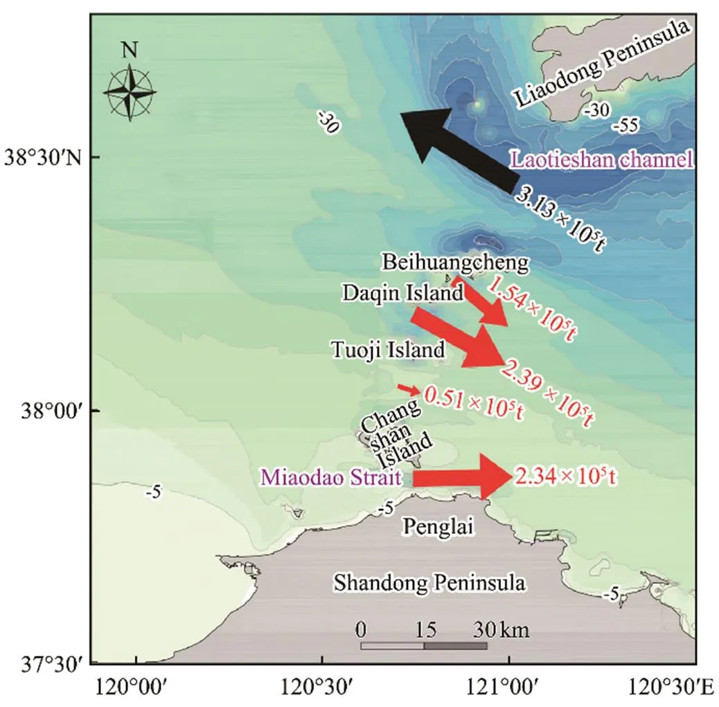
Fig.12 Net transport trend and SSF of each section. Red arrows represent the SSF from the Bohai Sea to the Yellow Sea; black arrow represents the SSF from the Yellow Sea to the Bohai Sea.
Moreover, the outflow exceeds the inflow of Bohai in August, with the net water flux of 1.4×10¹⁰m3,., same as the delivery of the rivers which flow into the Bohai Sea.Since the amount of sediments moving out from the Bohai Sea is larger than the amount in, one may conclude that sediments are mainly transported out of Bohai Sea through the Bohai Strait in August, which is in agreement with previous studies (Zhang., 2018). The estimate values offrom the Bohai Sea to the Yellow Sea reported in previous investigations ranged from 5 to 40Mtyr−1(Qin and Li, 1982; Martin., 1993; Bi., 2011). Theobtained in this study is 0.33Mt under the action of tidal currents in the Bohai Strait in August. If the whole year could be only divided into summer and winter, as suggested by Bi. (2011), theof the Bohai Strait in summer is 1.98Mt, which is in the range of the values reported in previous studies. Thes are the vertical average of 25h synchronously observed in summer, and the concentration references of each station are near the section. Meanwhile, the currents data simulated by one hour and the transport directions of suspended sediments are consistent with those presented in Section 4.2. Therefore, the results presented herein provide a more realistic insight of the suspended sediment flux in summer period.
The field observations showed that the suspended sediment transport was mainly controlled by advection and also influenced by vertical net circulation, while resuspension was relatively weak in Bohai Strait. Moreover, Euler residual currents are the main dynamic mechanism of suspended sediment transport in summer. The suspended se- diment flux varied between 3.8 and 89.1gm−1s−1, with the maximum value in the Miaodao Strait. Combined with the numerical simulation results, the sediment transport in the Bohai Strait can be found to follow the pattern of moving outward from the south, and inward from the north in summer,., the sediments are carried into the Bohai Sea through the Laotieshan channel, while out of the Boahi Sea through other channels. The outflow exceeds the inflow in August, with the net water flux of 1.4×10¹⁰m3, same as the delivery of the Rivers which flow into the Bo-hai Sea. Moreover, the net suspended sediment flux is esti- mated to be 0.33Mt under the action of tidal currents in the Yellow Sea in August.
Acknowledgements
This study was jointly funded by the Shandong Provi- ncial Natural Science Foundation, China (No. ZR2019 MD037), and the National Natural Science Foundation of China (No. 41776059).
Beardsley, R., Limeburner, R., Kim, K., and Candela, J., 1992. Lagrangian flow observations in the East China, Yellow and Japan Seas., 30 (3): 297-314.
Bi, N. S., Yang, Z. S., Wang, H., Fan, D., Sun, X., and Lei, K., 2011. Seasonal variation of suspended-sediment transport through the southern Bohai Strait., 93 (3): 239-247.
Bornhold, B. D., Yang, Z. S., Keller, G. H., Prior, D. B., Wiseman, W. J., Wang, Q.,., 1986. Sedimentary framework of the modern Huanghe (Yellow River) delta.,6 (2): 77-83.
Bowden, K. F., 1964. The mixing processes in a tidal estuary., 7 (6): 329-346.
Chen, S. L., 2000. Hydrodynamics, sediments and strait-channel effects for the Qiqu Archipelago., 22 (3): 123-131 (in Chinese with English abstract).
Duan, H., Xu, J., Wu, X., Wang, H., Liu, Z., and Wang, C., 2020. Periodic oscillation of sediment transport influenced by win- ter synoptic events, Bohai Strait, China., 12 (4): 986.
Fairley, I., Masters, I., and Karunarathna, H., 2015. The cumulative impact of tidal stream turbine arrays on sediment transport in the Pentland Firth., 80: 755-769.
Fang, Y., Fang, G. H., and Zhang, Q. H., 2000. Numerical simulation and dynamic study of the wintertime circulation of the Bohai Sea., 18(1): 1-9 (in Chinese with English abstract).
Guan, B. X., 1994. Patterns and structures of the currents in Bo- hai, Huanghai and East China Seas., 1: 17-26 (in Chinese with English abstract).
Hu, R. J., 2009. Sediment transport and dynamic mechanism in the Zhoushan Archipelago sea area. PhD thesis. Ocean University of China.
Hu, R. J., Ma, F., Wu, J., Zhang, W., Jiang, S., Xu, Y.,., 2016. Sediment transport in the nearshore area of Phoenix Island., 15 (5): 767-782.
Huang, D., Chen, Z. Y., and Su, J. L., 1996. Application of three- dimensional shelf sea model in Bohai Sea: I. Tidal current, wind-driven circulation and their interaction., 18 (5): 1-13 (in Chinese with English abstract).
Huang, D., Su, J., and Backhaus, J. O., 1999. Modelling the seasonal thermal stratification and baroclinic circulation in the Bohai Sea., 19 (11): 1485-1505.
Huang, S., Li, K., Jiang, G., and Lu, J., 2013. Research on water exchange in Pearl River Estuary based on MIKE3 model., 38 (8): 134-140 (in Chinese with English abstract).
Ingram, R. G., 1981. Characteristics of the Great Whale River plu- me., 86 (C3): 2017-2023.
Jay, D. A., Geyer, W. R., Uncles, J. R., Vallino, J., Largier, J., andBoynton, W. R., 1997. A review of recent developments in estuarine scalar flux estimation., 20 (2): 262-280.
Jiang, S. H., Wang, N., Cheng, H. Y., and Yin, Y. J., 2019. The study on hydrodynamic distribution characteristics of the Bohai Strait., 49 (S1): 66- 73 (in Chinese with English abstract).
Li, G., Tang, Z., Yue, S., Zhuang, K., and Wei, H., 2001. Sedimentation in the shear front of the Yellow River Mouth., 21 (6): 607-625.
Li, G., Xue, X., Liu, Y., Wang, H., and Liao, H., 2010. Diagnostic experiments for transport mechanisms of suspended sediment discharged from the Yellow River in the Bohai Sea., 20 (1): 49-63.
Li, J., Song, J., Mu, L., Wang, Y., Li, Y., and Wang, G. S., 2015. Characteristics of sea water exchange between Bohai Sea and Yellow Sea under the effect of high wind in winter., 34 (6): 647-656 (in Chinese with English abstract).
Lin, J. J., 2017. Suspended sediment distribution and transport mechanism in the Penglai inshore sea area. Master thesis. Ocean University of China.
Lin, X. P., Wu, D. X., Bao, X. W., and Jiang, W. S., 2002. Study on seasonal temperature and flux variation of the Bohai Strait., 32 (3): 355-360 (in Chi- nese with English abstract).
Lu, J., Qiao, F. L., Wang, X. H., Wang, Y. G., Teng, Y., and Xia, C. S., 2011. A numerical study of transport dynamics and seasonal variability of the Yellow River sediment in the Bohai and Yellow Seas., 95 (1): 39-51.
Martin, J. M., Zhang, J., Shi, M. C., and Zhou, Q., 1993. Actual flux of the Huanghe (Yellow River) sediment to the Western Pacific Ocean., 31 (3): 243-254.
Milliman, J. D., and Meade, R. H., 1983. World-wide delivery of river sediment to the oceans., 91 (1): 1-21.
Qiao, L., 2008. Circulation and sediments transport due winter storms in the Bohai Sea and Yellow Sea.PhD thesis. Ocean University of China.
Qiao, L., Zhong, Y., Wang, N., Zhao, K., Huang, L., and Wang, Z.,2016. Seasonal transportation and deposition of the suspended sediments in the Bohai Sea and Yellow Sea and the related mechanisms., 66 (5): 751-766.
Qin, Y., Zhao, Y., and Zhao, S., 1986.. Science Press, Beijing, 232pp.
Qin, Y. S., and Li, F., 1982. Study on the suspended matter of the sea water of the Bohai Gulf., 4 (2): 191-200.
Qin, Y. S., Li, F., Xu, S. M., Milliman, J., and Limeburner, R., 1989. Suspended matter in the South Yellow Sea., 20 (2): 101-112.
Uncles, R., Elliott, R., and Weston, S. A., 1985. Dispersion of salt and suspended sediment in a partly mixed estuary., 8 (3): 256-269.
Wan, X. Q., Bao, X. W., Wu, D. X., and Jiang, H., 2004. Numerical diagnostic simulation of tide-induced, wind-driven and thermohaline currents in the Bohai Sea., 35 (1): 41-47.
Wang, C. H., Liu, Z. Q., Harris, C. K., Wu, X., Wang, H. J., Bian, C. W.,., 2020. The impact of winter storms on sediment transport through a narrow strait, Bohai, China., 125 (6): 1-23.
Wang, H. J., Wang, A. M., Bi, N. S., Zeng, X. M., and Xiao, H. H., 2014. Seasonal distribution of suspended sediment in the Bohai Sea, China., 90: 17-32.
Wang, H. J., Yang, Z. S., Li, Y. H., Guo, Z. G., Sun, X. X., and Wang, Y., 2007. Dispersal pattern of suspended sediment in the shear frontal zone off the Huanghe (Yellow River) Mouth., 27 (6): 854-871.
Wang, J., Jin, P., Bishop, P. L., and Li, F., 2011. A preliminary study on water the turbidity distribution characteristics of in the North Yellow Sea in summer., 6 (2): 288-293 (in Chinese with English abstract).
Wei, Z. X., Li, C. Y., Fang, G. H., and Wang, X. Y., 2003. Numerical diagnostic study of the summertime circulation in the Bohai Sea and the water transport in the Bohai Strait., 21 (4): 454-464 (in Chinese with English abstract).
Wu, X., Wu, H., Wang, H., Bi, N., Duan, H., Wang, C.,., 2019. Novel, repeated surveys reveal new insights on sediment flux through a narrow strait, Bohai, China., 124: 1-15.
Xiao, H., Wang, H. J., and Bi, N. S., 2015. Seasonal variation of suspended sediment in the Bohai and Yellow Sea and the pathway of sediment transport., 35 (2): 11-21 (in Chinese with English abstract).
Yuan, X. D., 2018. Distribution and transport mechanism of suspended sediment in the southern Bohai Strait. Master thesis.Ocean University of China.
Zhang, Z., Qiao, F., Guo, J., and Guo, B., 2018. Seasonal changes and driving forces of inflow and outflow through the Bohai Strait., 154: 1-8.
Zhao, B. R., Cao, D. M., Li, H. C., and Lei, F. H., 2001. Tidal mixing characters and tidal fronts phenomenons in the Bohai Sea., 23 (4): 113-118.
Zhao, B. R., Zhuang, G. W., Cao, D. M., and Lei, F. H., 1995. Circulation, tidal residual currents and their effects on the sedimentations in the Bohai Sea., 26 (5): 466-473 (in Chinese with English abstract).
Zhu, S. X., Ding, P. X., Shi, F. Y., and Zhu, J. Y., 2005.Numerical study on residual current and its effect on mass transport in the Hangzhou Bay and the Changjiang Estuary II. Residual current and its effect on mass transport in winter., 22 (6): 1-12.
Zuo, S., Zhang, N., Li, B., and Chen, S., 2012. A study of suspended sediment concentration in Yangshan deep-water port in Shanghai, China., 27 (1): 50-60.
(April 15, 2021; revised July 19, 2021; accepted September 17, 2021)
© Ocean University of China, Science Press and Springer-Verlag GmbH Germany 2023
Corresponding author. E-mail: hrj@ouc.edu.cn
(Edited by Chen Wenwen)